gvSIG bugs #4758

Grainy visualization of MapServer WMS
| Status: | Outdated | % Done: | 0% | |
|---|---|---|---|---|
| Priority: | Normal | Spent time: | - | |
| Assignee: | - | |||
| Category: | WMS | |||
| Target version: | - | |||
| Severity: | Major | Add-on version: | ||
| gvSIG version: | 2.3.1 | Add-on build: | ||
| gvSIG build: | Add-on resolve version: | |||
| Operative System: | Add-on resolve build: | |||
| Keywords: | Proyecto: | |||
| Has patch: | Hito: | |||
| Add-on name: | Unknown |
Description
- open "Add layer", WMS tab;
- connect to http://demo.mapserver.org/cgi-bin/wms? and add the "World country boundaries" layer to a view;
- for instance, zoom on your country.
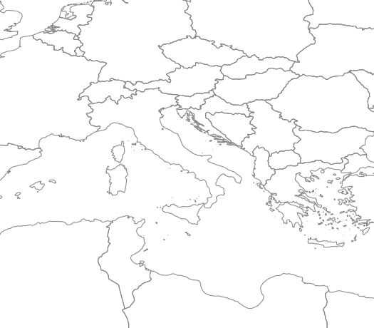
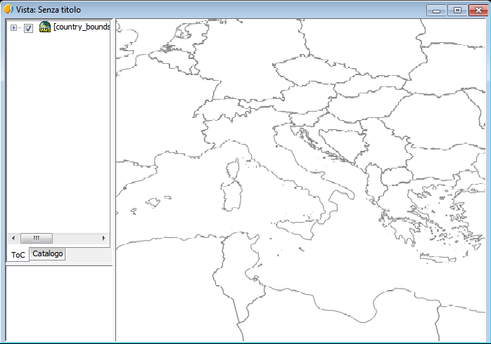
Result: the layer appears fine initially, while after zooming it's a bit grainy. Instead, the images in tmp-gvsig/downloader are fine.
I attach a screenshot and the image from the relative getmap request:


History
#1
 Updated by Antonio Falciano over 8 years ago
- Format: image/png (with transparency)
- SRS: CRS84
- Info: text/html
View CRS: EPSG:4326
#2
 Updated by Joaquín del Cerro Murciano over 8 years ago
- Target version changed from 2.4.0-2850-final (rev. org.gvsig.desktop-2.0.220) to 2.5.1-3044
#3
Updated by Antonio Falciano over 8 years ago
For instance, this bug affects also the official Italian Cadastre WMS service:
https://wms.cartografia.agenziaentrate.gov.it/inspire/wms/ows01.php
#4
 Updated by Álvaro Anguix over 8 years ago
Curiously, if you select the option 'use of local tile cache' the visualization is good, without 'grainy'
#5
Updated by Antonio Falciano over 8 years ago
Álvaro Anguix wrote:
Curiously, if you select the option 'use of local tile cache' the visualization is good, without 'grainy'
Yes, it works fine using the local tile cache or using a CRS different from CRS:84... I've just discovered that the issue depends by CRS:84 (no auth repository), so it's not a specific WMS one:
WARN 84354 AWT-EventQueue-0 org.gvsig.crs.Crs - Can't get proj4 string from CRS:84
java.lang.RuntimeException: OGR Error: Unsupported SRS
    at org.gdal.osr.osrJNI.SpatialReference_ImportFromEPSG(Native Method)
    at org.gdal.osr.SpatialReference.ImportFromEPSG(SpatialReference.java:547)
    at org.gvsig.crs.Crs.initFromSpatialReference(Crs.java:129)
    at org.gvsig.crs.Crs.<init>(Crs.java:241)
    at org.gvsig.crs.repository.NoAuthRepository.getCrs(NoAuthRepository.java:98)
    at org.gvsig.crs.CrsFactory.getSimpleCRS(CrsFactory.java:170)
    at org.gvsig.crs.CrsFactory.getCRS(CrsFactory.java:115)
    at org.gvsig.crs.CrsFactory.get(CrsFactory.java:232)
    at org.gvsig.fmap.crs.CRSFactory.getCRS(CRSFactory.java:61)
    at org.gvsig.raster.wms.io.WMSProvider.loadInitialInfo(WMSProvider.java:262)
    at org.gvsig.raster.wms.io.WMSProvider.init(WMSProvider.java:229)
        [...]
#6
Updated by Álvaro Anguix about 6 years ago
- Target version deleted (
2.5.1-3044)
#7
Updated by Álvaro Anguix about 6 years ago
- Status changed from New to Outdated
El servidor indicado no funciona actualmente.